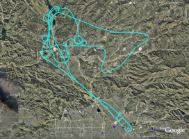
Solo to the Valley
Aircraft: Cessna 172M – N13818
Length of Flight: 1.8 Hrs – Solo
Total Flight Hours to Date: 32.7 Hrs
Altitude: 3500 Feet
Route: Whiteman to Whiteman
![]() Click to download the Google Earth flight path.(Google Earth Help)
Click to download the Google Earth flight path.(Google Earth Help)
This is the first time logging my flights with my GPS. If you click on the link above for the Google Earth you can fly the route that I flew! It’s really cool. Look in the Google Earth Help for how I set mine up for a cool tour.
When you’re learning how to fly you have basic maneuvers that you have to perform for the instructor. I was practicing some of those maneuvers on this flight. If you look at Google Earth or the photo you see all the little circles, those are called turns around a point. It’s a maneuver where you want to do a nice gradual turn around a fixed point on the ground. At the same time you have to keep your airspeed and altitude the same, which at first can be harder than it seems. When you’re driving you only have right and left to worry about, when you’re flying you have right/left, up/down and roll left/roll right. It’s so fun! I flew out over Castaic Lake and checked out all the boaters, and then over Magic Mountain to see how busy it was. I didn’t take any photos on this flight, sorry.

